What’s the Walkability Score of Your Address?
- Published on
- 8 min read
-
 Richard Haddad Executive EditorClose
Richard Haddad Executive Editor
Richard Haddad Executive EditorClose
Richard Haddad Executive EditorRichard Haddad is the executive editor of HomeLight.com. He works with an experienced content team that oversees the company’s blog featuring in-depth articles about the home buying and selling process, homeownership news, home care and design tips, and related real estate trends. Previously, he served as an editor and content producer for World Company, Gannett, and Western News & Info, where he also served as news director and director of internet operations.
When you’re buying a home, there’s more to consider than just the property itself. Some neighborhoods can look perfect online, but the real test comes when you’re actually living there, stepping out for coffee, grabbing groceries, or heading out for a quick dinner.
The right neighborhood fits naturally into your everyday routine. If you can walk to essentials or meet friends without planning your whole day around it, that convenience makes a big difference. That’s where it helps to look at something called a walkability score by address, a simple way to measure how easily daily life actually works in a neighborhood before you decide where to buy.
Find Walkable Communities with an Expert
A walkability score by address can point you in the right direction, but it does not always tell the full story of a neighborhood. Partner with a local real estate agent to understand what those scores really mean on the ground and find a home that fits how you actually want to live day to day.
In this post, we’ll guide you through everything you need to know about walkability scores: how they work, where to find them, and how they can affect homebuying decisions.


What is a walkability score by address?
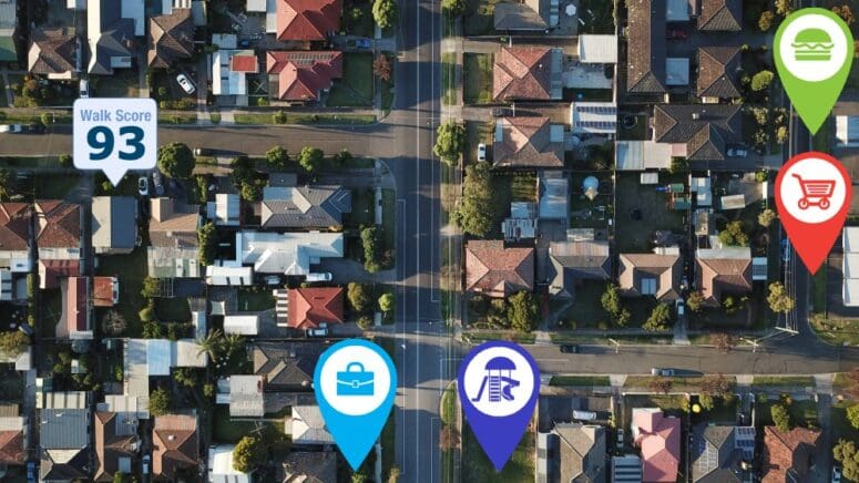
A walkability score is a number from 0 to 100 that shows how easy it is to get around and do daily errands on foot from a specific address. It’s a quick way to see if a neighborhood fits a more walkable lifestyle and how convenient it would be to live there without needing a car all the time.
This score is especially helpful for homebuyers who want a neighborhood that fits their lifestyle, especially one where amenities like shops, parks, and schools are only a short walk away.
How do walk scores work?
A walk score is simple in concept but very informative: It uses data to assign any address a number between 0 and 100 based on how walkable it is. For example, one of the most widely used tools in the U.S. is WalkScore.com, which calculates its ratings using a patented system that analyzes hundreds of walking routes to nearby amenities.
In general, the closer the essentials are, the higher the score, especially across categories like:
- Dining and drinking
- Groceries
- Shopping
- Errands
- Parks
- Schools
- Culture and entertainment
Places within a five-minute walk get the most points, while things farther away get fewer points, with anything beyond a 30-minute walk basically not counting. The score also considers pedestrian-friendliness factors, including population density and road metrics like block length and intersection density.
To gather this data, walkscore.com relies on various platforms, such as Google, Factual, Great Schools, Open Street Map, the U.S. Census, Localeze, and user contributions, ensuring a broad and accurate representation of an area’s walkability.
Walk Score points system
- 90–100 Walker’s Paradise: Daily errands do not require a car
- 70–89 Very Walkable: Most errands can be accomplished on foot
- 50–69 Somewhat Walkable: Some errands can be accomplished on foot
- 25–49 Car-Dependent: Most errands require a car
- 0–24: Car-Dependent: Almost all errands require a car
Walk Score examples
To put these scores into perspective, consider the following two contrasting examples from WalkScore.com:
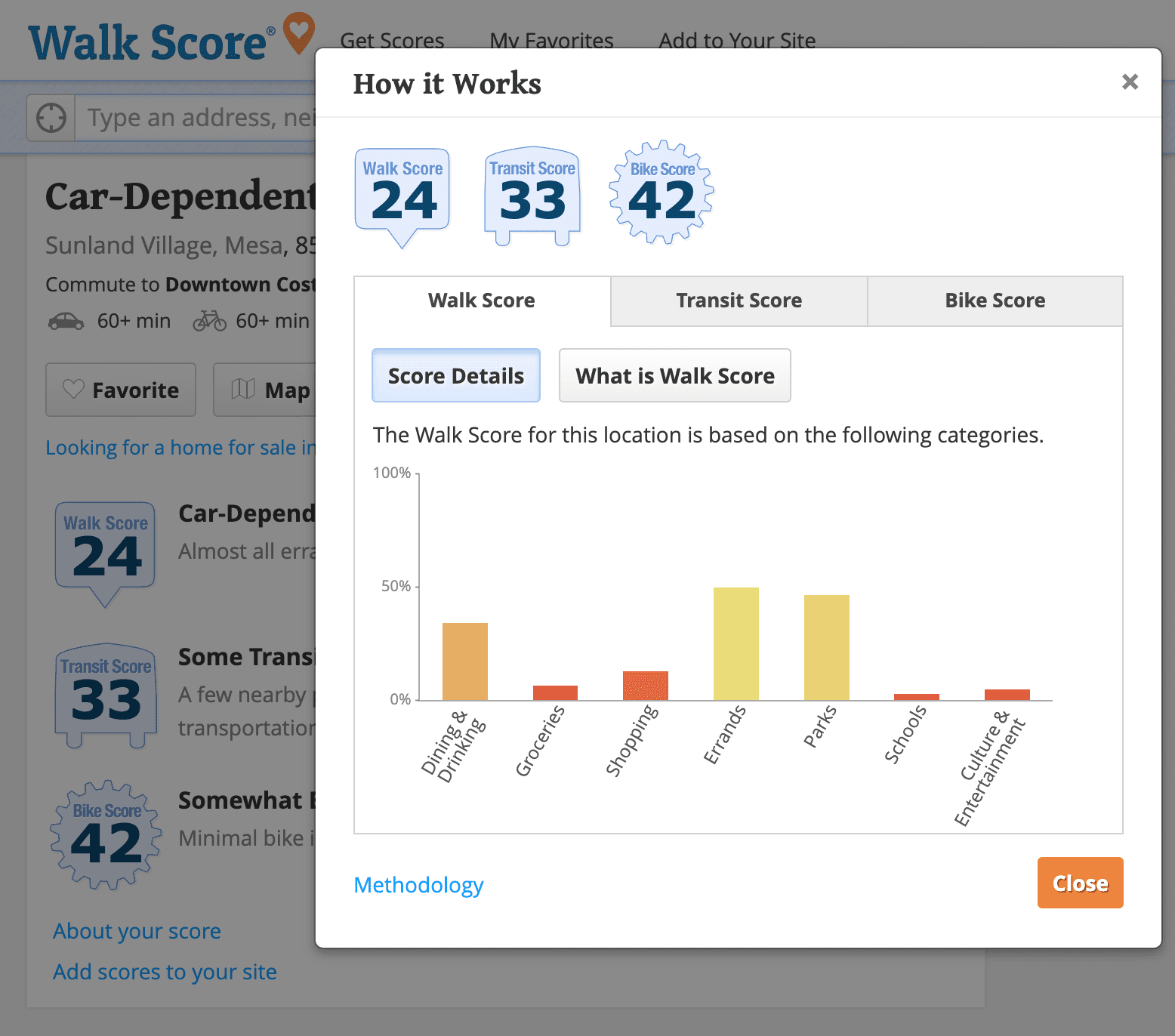
Sunland Village in Mesa, Arizona, is deemed “Car-Dependent” with a low walkability score of 24, indicating that almost all errands require a car. This southeastern suburb of Phoenix also scores low for transit and bike use.
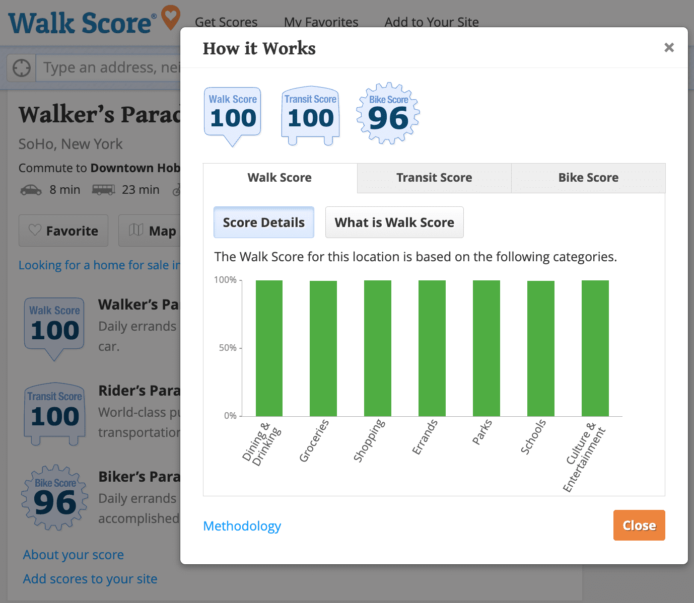
SoHo in New York, on the other hand, is a “Walker’s Paradise” with a score of 100, where daily errands do not necessitate a vehicle. Transit and bike scores are also rated high.
These examples highlight the stark differences in walkability and, consequently, the lifestyle one might expect in these locations.
WalkScore.com doesn’t just look at walking. It also includes a Transit Score for how easy it is to use public transportation and a Bike Score for how convenient it is to get around by bike.
When you combine these scores with information about nearby amenities, you get a much clearer idea of how livable a home really is. It helps bridge the gap between listing details and real-life convenience.
What are some examples of walkable cities?
If your ideal day involves grabbing coffee, picking up groceries, and meeting friends without hunting for a parking spot, these cities below are worth a look. According to WalkScore.com, they rank among the most walkable in the country, making it easier to fit everyday errands and spontaneous outings into your routine.
San Francisco (Walk Score: 89)
In San Francisco, a quick walk can take you from a neighborhood café to a grocery store, a park, or your favorite takeout spot. The city’s most walkable neighborhoods include Chinatown, Tenderloin, and Polk Gulch, where daily essentials are often just a few blocks away.
Getting around is even easier thanks to the Bay Area Rapid Transit (BART), which connects much of the city to the broader Bay Area. If you’re hoping to spend less time behind the wheel and more time enjoying the neighborhood, San Francisco is a good option. Take a look at homes for sale in San Francisco.
New York City (Walk Score: 88)
New Yorkers are famous for walking everywhere, and the city’s walk score helps explain why. In neighborhoods like Union Square, Chinatown, and NoHo, residents can walk to an average of nine restaurants, bars, or coffee shops in just five minutes.
Whether it’s a late-night slice of pizza, a morning bagel run, or an impromptu dinner plan, chances are it’s right around the corner. Add one of the world’s most extensive transit systems, and getting from Point A to Point B becomes part of the city’s charm. Start exploring homes for sale in New York City.
Boston (Walk Score: 83)
Boston proves that centuries-old streets can still work pretty well for modern life. Walkable neighborhoods like Beacon Hill, Chinatown-Leather District, and the North End make it easy to get around on foot while soaking up plenty of local character along the way.
From historic brownstones to cozy cafés and waterfront views, many of the city’s best experiences are just a short stroll apart. It’s the kind of place where a simple errand can turn into a scenic walk. Check out homes available for sale in Boston.


How are walkability scores by address used?
Walk scores give you a simple, number-based way to understand how easy it is to get around an area on foot, and they end up shaping decisions across housing, development, and city planning. Some common uses include:
- Homebuyers and renters use walkability scores to find neighborhoods that fit their lifestyle, especially places where everyday essentials are close by and easy to walk to.
- Urban planners and developers use walk scores to design communities that are more walkable, less car-dependent, and generally more livable.
- Real estate professionals use these scores to market properties, highlighting walkability as a key feature that helps homes stand out.
Other resources for walkability scores by address
WalkScore.com gives a pretty solid overall view of walkability, but there are also other tools that can help you understand how easy it is to get around a specific neighborhood or area. Resources from groups like the U.S. Environmental Protection Agency (EPA) and the U.S. General Services Administration (GSA) offer interactive maps and data that let you dig into things like walkability and transit access in more detail.
National Walkability Index
The National Walkability Index is basically a map-based tool that shows how walkable different areas are across the U.S. It ranks neighborhoods based on things like how dense they are, how mixed the land use is, and how close they are to transit. It’s a quick way to get a sense of how easy it is to get around a specific area on foot or by public transport.
Access to Jobs and Workers Via Transit Tool
This tool focuses on how easily people can access jobs from different neighborhoods using public transit. It measures how well residents can reach employment opportunities and how easily workers can get to job centers without needing a car. Combining transit data across metro areas, it gives a clear view of how transportation connects people to work.
Smart Location Calculator
If you’re curious about how a workplace location affects your commute, the Smart Location Calculator is a helpful tool. It scores addresses based on how efficient their location is and breaks things down at the block group level. It also goes beyond walkability, looking at things like commute-related emissions, transportation choices, vehicle miles traveled, and how easily people can reach jobs by transit.
Estimate Home Values in Walkable Cities
Thinking about buying in a walkable city? Use HomeLight’s Home Value Estimator to see what homes are worth in the neighborhoods you’re considering and get a better sense of what your budget can buy.
More helpful tools when moving to a new community
Moving to a new community comes with a lot of unknowns, especially when you’re trying to figure out if a place will actually fit your day-to-day life. Beyond just listings and home prices, there are tools that can help you understand things like commute times, walkability, and overall livability. Here are some helpful resources to make that research a little easier.
Cost of living indexes
- C2ER cost of living index
- Statista Cost of Living Index by State
- World Population Review Cost of Living Index by State
- Numbeo’s Current Cost of Living Index
Cost of living calculators
Livability indexes and calculators
Crime maps


Migration maps (where people are moving)
Move cost estimators
Living wage and budget calculators
- Living Wage Calculator (Massachusetts Institute of Technology)
- Family Budget Calculator: (Economic Policy Institute)
Homebuyer calculators
Home seller calculators


A top agent can offer expert walkability insights
Walkability scores and the tools we’ve shared can be helpful when you’re planning a move, giving you a quick sense of daily life, costs, and the convenience of different neighborhoods. But a local real estate agent can take it a step further by sharing what those neighborhoods are actually like in real life, not just what the numbers say.
These experts know the little details that make an area feel right, from walkability to overall livability and what residents really think. Whether you’re buying, selling, or doing both, HomeLight can connect you with top-rated agents in your market who can help you make smarter decisions about walkability and everything else that comes with it.
Header Image Source: (Tom Rumble/Unsplash)
At HomeLight, our vision is a world where every real estate transaction is simple, certain, and satisfying. Therefore, we promote strict editorial integrity in each of our posts.